Coastal protection – Infrastructure or risk management under uncertainty
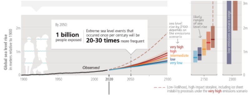
Coastal change is accelerating, and the cost of inaction compounds over time. Sea levels are rising for most major coastal cities, extreme water levels are shifting (a small rise in mean sea level moves today’s flood curve, turning events we once saw as rare into events that occur more often), and capital cycles rarely align with the pace at which risk evolves. In this environment, resilient outcomes don’t come from a single structure or design level. They come from systems that reduce hazard, exposure, and vulnerability together and that are intentionally designed to adapt over time.
That is why modern coastal protection is best framed as a risk management and decision-making challenge under uncertainty, not simply an engineering works program. The cities that are making the most progress are not chasing one “big wall” (a continuous, fixed barrier). Instead, they are building layered systems that manage risk across multiple pathways and scales, then adapting those systems as conditions change. This mental model has been reinforced repeatedly through practice across Australia, Singapore, Europe, the US, and elsewhere.
Think in a chain: Hazard → Assets → Damage → Mitigation
Best practices in risk management start by linking four questions in one workflow:- What can happen (the hazards and likelihood)?
- What matters (the exposure – assets and services)?
- How bad it can be (the vulnerability – damage and disruption)?
- What we do about it, when and in what sequence (mitigation, operations, and pathways)?
When planning moves beyond exposure maps and includes consequences, it unlocks a much broader and more effective toolbox: property level resilience measures such as elevation raising, dry or wet floodproofing become legitimate options. Back of wall drainage control, tide gates, and one-way valves become more important. Hybrid and nature-based solutions can be evaluated alongside engineered structures, and non-structural measures such as emergency management, insurance, and recovery planning become part of the same conversation. As recent works emphasize, the hazard–asset–damage evaluation may provide a pragmatic framework to systematically assess a wider range of mitigation options and help cities prioritize and sequence investments.
.png)
Designing for exceedance and planning for residual risk
Events like hurricanes Katrina and Sandy taught the world that no defense eliminates risk entirely. Crucially, every credible coastal defense strategy today will be exceeded at some point. Experience from major flood events, as well as portfolio-level risk assessments, shows that a disproportionate share of expected losses sits in rare but plausible exceedance events. This reality has two important implications. First, coastal infrastructure should be designed with safe-to-fail behavior in mind, allowing controlled overflow and limiting catastrophic consequences rather than assuming absolute protection. Second, engineering solutions must be matched with operational readiness: early warning systems, evacuation planning, continuity strategies for critical assets, and clear recovery playbooks. This is particularly important in cyclone-exposed regions and densely built port-city interfaces, where compound flooding driven by storm surge, rainfall, and high tide can exploit “back-door” pathways behind coastal defenses.
Prioritize with simple methods, save modeling depth for when it counts
At a city or portfolio scale, progress often comes from resisting the temptation to over-engineer too early. The most effective programs use fast and consistent screening methods to map plausible flood extents, link them to asset exposure, and translate that information into indicative damage and risk, with transparent caveats. More complex, coupled modeling is then reserved for shortlisted locations where it will genuinely affect decisions. It’s not about perfection; it’s about comparability across many sites, so decision makers can direct scarce resources to more impactful actions while deeper studies proceed where they matter. Two guardrails are essential: being explicit about limitations upfront, and always tying analytical outputs back to consequences, feasibility, and deliverability.
Layered, adaptive systems outperform single-line defenses
Around the world, the most durable coastal solutions take the form of layered, adaptive systems rather than single-purpose structures. Offshore or nearshore measures such as reefs, headlands, or beach nourishment are used where feasible to manage wave energy. Shoreline-edge interventions, including walls, revetments, pocket beaches, and living shorelines, are tailored to local context and amenity. Behind the shoreline, drainage controls, tide gates, overflow corridors, and micro-basins address compound flooding and tide-locking. At the asset and network level, elevation, floodproofing, and redundancy in power, water, telecommunication and transport systems (e.g., backup power for critical facilities) reduce vulnerability even when water finds a way in. What distinguishes leading practice is that these layers are not treated as static solutions; they are organized along adaptive pathways, with predefined decision points linked to/triggered by sea level rise, overtopping (wave run up & overflow sea defenses) frequency, service disruption, or asset renewal cycles. This allows cities to scale or pivot over time without over- or under-building.
Program before project: standards, governance, and equity
Equally important is recognizing that program design matters as much as project design. New York City’s experience over the past decade is instructive, not because of any single project, but because of how the city has structured its coastal resilience efforts. Citywide standards and climate-informed design guidance are paired with multi-hazard, equity-centered planning. Coastal initiatives are aligned with hazard-mitigation funding pathways, and a catalog of repeatable project typologies, from raised shorelines and deployable barriers to living shoreline modules, cloudburst streetscapes, and property-level measures, allows concepts to be developed, combined, and advanced efficiently. The payoff is governance clarity, agency alignment, and funding readiness, while keeping community concerns and delivery outcomes front-of-mind.
Implications for high-density, high-value coastal city-states
For heavily urbanized, densely built, and high-value city-states like Singapore, these lessons translate particularly well. For example, Singapore’s coastal challenge is uniquely urban: limited sediment supply, constrained shorelines, and nationally significant assets concentrated at the water’s edge. The global playbook suggests clear priorities. Decisions should be driven by consequences, not contours, pairing flood extents (flooded areas) with impacts (tangible & intangible losses) and service-level metrics to prioritize investments and justify non-structural measures where they deliver greater risk reduction per dollar. Equal attention should be paid to engineering the “back door,” recognizing that tidal gates, backflow prevention, graded overflow paths, and operational protocols can be as important as the seaward line of defense. Adaptive pathways and triggers should be embedded into policy and project approvals so that upgrades and sequencing are pre-agreed, funding-eligible, and faster to deliver when thresholds are crossed. Finally, standardization matters: maintaining a coherent catalog of typologies with consistent design bases (Code of Practice) and operational expectations allows solutions to be scaled from one reach to the next without restarting the conversation each time.
The uncomfortable but necessary caveats
Screening-level assessments should not be taken as a substitute for design; waves, morphology, and drainage interactions must be resolved through detailed studies before committing major capital. Uncertainty never disappears, particularly for rare events and future storm behavior. Numbers should be used to inform decisions not predict outcomes, with residual risk clearly documented and managed through preparedness, insurance, and recovery planning. Perhaps most importantly, governance itself is a design variable. Without clear responsibilities, agreed standards, and reliable funding pathways, even the best technical concepts will stall. Building the program “plumbing” early is often what determines whether good ideas are delivered or remain on paper.
When we reframe coastal protection as managing risk across a moving probability distribution, the solutions that emerge are naturally layered, adaptive, and deliverable. They are engineered not only to perform under design conditions, but to exceed them safely and recover quickly. That is how future-ready built environments, particularly in coastal zones from the Netherlands to New York, from Australia to Singapore, are protecting people, assets, and places.
Connect with us to develop coastal protection strategies that adapt over time, reduce risk, and deliver resilient outcomes where it matters most.
About the author

Ryan Nguyen
Senior Coastal Engineer, Ports and Terminals
Ryan is a civil and coastal engineer with over 20 years of experience in coastal protection, ports and marine infrastructure, and climate‑resilient projects. He specializes in designing and delivering structural solutions for maritime assets, supported by expertise in numerical modelling, GIS, programming, and risk‑based approaches. Ryan has led complex national programs, developed technical guidelines and strategic tools, and helped shape long‑term adaptation strategies that reduce coastal risk and strengthen resilience to climate change.